The Lleyn Peninsula is one of Wales's hidden treasures, an isolated area of sandy beaches, varied towns and spectacular views, with a history as a centre of pilgrimage. The area now mixes a thriving tourist industry on the coast with farming and the odd scattered industry in the interior.
 Most of the major settlements of the Lleyn are on the south coast, running from Porthmadog at the far eastern end, past Criccieth with its castle, the shopping centre of Pwllheli and the busy boating centre of Abersoch and ending with the atmospheric village of Aberdaron, almost at the western tip of the peninsula. The north coast is lined with quieter villages (many with handy individual shops). The tourist will rarely visit the villages in the interior, although Sarn Meyllteyrn on the road to Aberdaron has a varying collection of small shops (on our last visit a good café, idiosyncratic pottery, café, pub and good general store).
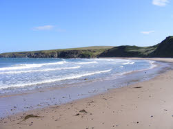
There are excellent beaches on both coasts, some easy to reach, others really remote. Starting at the south-east corner we have Black Rock Sands, just west of Porthmadog. Criccieth has small and partly rocky beaches. Abererch had a long beach backed by dunes that runs west to Pwllheli. Pwlleheli has two beaches - the east beach where Abererch beach reaches the town and south beach, lined with elegant buildings and again backed by dunes.
Llanbedrog Beach is vast at low tide, sheltered from westerly winds, has a nice café and great views back towards Snowdonia and mid-Wales. Abersoch sits between two beaches, one that runs north towards Llanbedrog and the other heading south towards Machroes, a small village with a handy car park. Porth Ceiriad, to the south of Abersoch, is one of the harder beaches to reach.
The biggest beach is Porth Neigwl or Hell's Mouth. This fast sandy expanse is best known as a danger to shipping, but it is also an increasingly popular beach and on a good day the small car park can be overwhelmed.
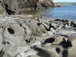
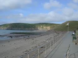 At the western tip Aberdaron has a lovely varied beach, backed with grassy slopes and sandy cliffs and bordered to the west with rocky cliffs. Finally Porth Meudwy, just west of the village, is a fine rocky cove with an active fishing industry, the boats to Bardsey Island and access from a small National Trust car park (walk required).
 Heading back along the north coast the first major beach is Porth Oer or Whistling Sands - once again there is a National Trust car park (with quite a steep road down to the beach). There is also a café on the beach, selling food, drinks and some beach goods.
To the north of Whistling Sands is Porth Iago, a steep sided cove facing west, famous for its splendid waves. Access here is from a private car park. Heading further up the coast we reach Porth Colmon and Traeth Penllech, sharing a single bay and with some parking at the western end and in the centre.
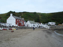 A long gap follows before we reach Morfa Nefyn, and Porth Dinllaen. This long sandy beach faces north, and sits below sandy cliffs. Against there is a National Trust car park (about half way along the beach), with a flight of steps down to the beach. At the western end of the beach is the village of Porth Dinllaen, with no vehicle access for visitors. Instead either walk along the beach or follow the right of way along the golf club road to reach this quiet harbour (with excellent pub). Next along the coast is Nefyn, with another long sandy beach. This time access is via a steep road with parking alongside the road, tilted sideways at a steep angle (so steep that it upset the fuel gauge on my car, which was convinced the tank had emptied!). Finally, at the northern-eastern corner of the Lleyn is a small beach at Trefor, facing towards Anglesey. Between Trefor and Nefyn is the Welsh Language Centre at Porth y Nant, once a lost village and now a thriving cultural centre at the bottom of a rather steep and winding road (resembling a mountain pass). Alternately park at the forest north of Llithfaen and walk down the road).
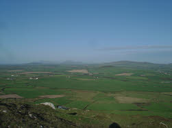
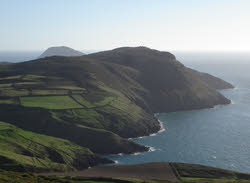 Most of the peninsula is gently rolling countryside, but there are some notable hills and mountains. At the western end is Mynydd Mawr, the 'land's end' of Wales. It is possible to dry to the top of this mountain, with its spectacular views east along the full length of the peninsula and west out towards Ireland (so I'm told). A couple of miles to the north-east is Mynydd Anelog, slightly taller and with a surprising lack of clear paths to the top.
Next in line is Mynydd Rhiw, a long narrow mountain that overlooks Hell's Mouth. Again it is possible to park close to the top and the views are great!
 In the centre of the peninsula is Carn Fadryn, an impressive steep sided mountain that dominates many views up and down the Lleyn. Carn Fadryn is surprisingly easy to climb - park at Garnfadryn village and follow the clear path that cuts between Carn Fadryn and the smaller Garnfadryn, then in the pass turn left to reach the summit.
The main area of high ground on the Lleyn starts at Garn Boduan, just south of Nefyn, and runs north-east along the coast, peaking at Yr Eifl, a cluster of steep sided mountains, some topped with forts or early settlements. The ground briefly drops (and the pass is crossed by the road to Caernarvon from Pwllheli) before rising again to Bwlch Mawr. After that the land drops again, and the next high ground is part of Snowdonia.