 The Yorkshire Wolds are perhaps the most scenic area in England without any legal protection, possibly because much of the area is farming land. The Wolds are a curved area of hills that run from Bridlington on the East Coast to the Humber just west of Hull. The highest areas of the Wolds are found in the north-western corner (actually close to the main A166 York to Driffield road).
 The outside of the curve tends to end quite abruptly, with steep escapements dropping down to the Vale of York in the west and The Carrs to the north. In this direction the outer limits of the Wolds are marked by the valley of the River Derwent, which follows a remarkable course from the North York Moors to the Humber. The river rises below Lilla Howe, high in the eastern part of the moors. It then runs south-east through the Moors, eventually getting to within four miles of the coast at Scarborough. At this point the river cuts south through the Forge Valley and emerges from the Moors between the villages of East Ayton and West Ayton. It then turns away from the sea and flows west between the Moors and the Wolds, reaching Malton where it turns towards the south, flows around the western edge of the Wolds and runs into the River Ouse near the Drax power station. There the water finally turns east and runs down the Ouse and then the Humber to finally reach the sea.
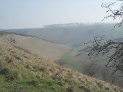
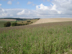
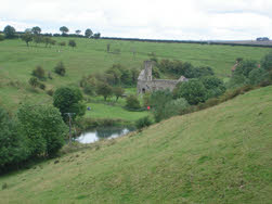
The character of the area is created by the unusual shape of the landscape. Most of the area is made up of very gently rolling hills, cut across by long straight roads and with the odd patch of woodland. The plateau is cut into by a series of narrow steep sided valleys, often forming elaborate networks, and almost invariably dry.
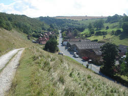 The Wolds are unusual in that the tops of the hills are mainly arable, while the steep dry valleys are wilder and contain forestry and livestock. Sadly many of these valleys lack footpaths, but enough of them are accessible to allow creation of a range of walks. Quite a few also contains roads, and even the odd village - Thixendale being perhaps the most impressively located at the hub of a network of valleys.
This landscape can also produce some much harder walks than one might expect - if you go against the grain of the valleys you can gain and lose a surprising amount of altitude in a short distance (The Wolds Way north of Thixendale again being a good example).
 There are two main long distance footpaths in the Wolds. The Wolds Way itself follows the curve of the hills and runs from Filey on the North Sea coast down to the Humber at North Ferriby and then along the river to the Humber Bridge (technically it starts at Hessle Haven). The northern part of the Wolds Way also overlaps to a certain extent with the Yorkshire Centenary Way, which runs from York to Filey.
The Wolds contains one of the most studied of the thousands of abandoned medieval villages in England - Wharram Percy (just south of Wharram le Street). This village was finally abandoned in about 1500 leaving only a ruined church. The village was the subject of a long archaeological dig led by Hull University and the locations of a number of the abandoned long houses can now be traced on the ground.