 This is one of the classic shorter walks in the Lake District, visiting Castle Crag, a minor peak, but in a fantastic location at the mouth of Borrowdale, and with views deep into the valley and along Derwent Water towards Keswick.
Ascent: 840ft/ 256m
Length: 3 miles/ 4.8km
Map: The English Lakes - North Western Area (OS Explorer Map Active) (OS Explorer Map Active)
Last Walked: 11 October 2007
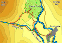
We start at the National Trust car park in Rosthwaite.
![]() This track brings us to a set of stepping stones that cross the river. Head across the stepping stones (if the water isn't too high), then turn right and follow the riverside path. If the stepping stones aren't usable, turn right on the near side of the river and follow a track to the New Bridge, crossing the river there instead.
This track brings us to a set of stepping stones that cross the river. Head across the stepping stones (if the water isn't too high), then turn right and follow the riverside path. If the stepping stones aren't usable, turn right on the near side of the river and follow a track to the New Bridge, crossing the river there instead.
![]() Continue on along the river for about 600 feet, until the path turns left to skirt around a very wet field. Follow this path until it turns right to head back towards the river. At this point leave the riverside path and take the clear path that climbs up the hillside towards the trees that blanket Castle Crag.
Continue on along the river for about 600 feet, until the path turns left to skirt around a very wet field. Follow this path until it turns right to head back towards the river. At this point leave the riverside path and take the clear path that climbs up the hillside towards the trees that blanket Castle Crag.
![]() Follow this path through the trees. Ignore the route shown on OS maps - the actual path curves to the left, crosses a wall and reaches a shoulder of open level ground to the south of Castle Crag. Follow the path across the open ground to a stile at the northern tip of the field.
Follow this path through the trees. Ignore the route shown on OS maps - the actual path curves to the left, crosses a wall and reaches a shoulder of open level ground to the south of Castle Crag. Follow the path across the open ground to a stile at the northern tip of the field.
![]() The actual path to the summit doesn't visit the quarries, but instead passes around their right, heading up to the small summit plateau along an artifical ridge created by the
The actual path to the summit doesn't visit the quarries, but instead passes around their right, heading up to the small summit plateau along an artifical ridge created by the ![]() excavations (it is well worth exploring the quarries). The summit contains the Borrowdale War Memorial, and is a fantastic viewpoint, but it is also a dead-end, so after you have finished here retrace your steps down the spoil heap.
excavations (it is well worth exploring the quarries). The summit contains the Borrowdale War Memorial, and is a fantastic viewpoint, but it is also a dead-end, so after you have finished here retrace your steps down the spoil heap.
![]() Turn left onto this path, with the valley to our left and the slopes of High Spy to our right. Follow this path as it curves around into the valley of Tongue Gill.
Turn left onto this path, with the valley to our left and the slopes of High Spy to our right. Follow this path as it curves around into the valley of Tongue Gill.
We follow this path as it curves right, heading up the valley of Tongue Gill. Eventually the path passes through a gate and reaches the stream. Cross the stream via a ford just beyond the stream, and then turn left onto a path that runs down the right-hand bank of the gill. Follow this path all the way down to the River Derwent.