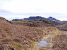
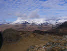
 Green Crag sits just back from Eskdale, and isn't really seen from the valley, but it it a satisfyingly craggy summit, with great views towards the upper reaches of the valley and the circle of mountains that run from Scafell to Crinkle Crags.
About half of this walk is either on very vague paths or off paths entirely, so only try it if you are comfortable with making your way across that sort of terrain. The ascent of Green Crag stays on clear paths until the final ascent, but our return route tends to wander rather more.
Ascent: 2,000ft
Length: 7 miles
Map:  Lakes South West
Last Walked: 2011
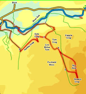
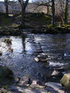
We start at a small car park close to Boot - look for the side road that branches off west of Boot (next to the war memorial). Follow this lane as it crosses the Esk - the car park is just past the river.
1: NY 170 002
Turn right out of the car park and follow the road back across the Esk Continue on for a short distance, then turn right onto a rough track. Follow this track as it swings a bit away from the river, before eventually it joins the lane leading to the church. Turn right onto this lane, then at the river turn left and follow a track that runs alongside the Esk.
2: NY 176 002
This track soon brings us to a footbridge over the river. Cross this bridge and then continue on upstream on the opposite bank to before..
3: NY 188 003
 We follow this track alongside the river for about a mile. Towards the end we pass alongside Great Coppice (with the wood to our right). At the end of the woods branch right onto a footpath. This runs alongside the eastern end of the woods and then emerges into a field. At this point follow a path that cuts diagonally across the field,
 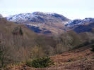 soon reaching a better quality track. Follow this track as it runs to the opposite corner of the field, climbing as it goes.
After leaving the field this track continues to climb up the steep side of the valley, zigzagging as it goes. We pass the ruins of a stone building, probably an old peat store (peat would be cut from the bog further up the track and carried down to this half-way house ready for use as fuel).
4: SD 193 995
The track remains very clear all the way to the top of the valley, where it emerges onto a plateau (the peat bog). At this point the track becomes a bit less clear, but a reasonably easy to follow path does continue in the direction we need. There is a clear dividing line here between the drier slopes to the left and the bog to the right. Look for a path that runs along this dividing line, normally staying on the drier side of the line.
5: SD 196 985
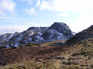
We stay on this path until we draw level with the gap between The Pike and Green Crag. At this point a simple grassy slope breaks the line of otherwise impenetrable crags - turn left and climb up this slope until you reach the col between the two crags. At this point the back of Green Crag comes into view and a easy route up to the summit comes into sight. Make your way to the summit up the eastern slopes of the crag.
6: SD 200 982
At this point you can retrace your steps back down into Eskdale, or you can follow our alternative route. Head back to the col, and this time follow the path that heads up towards The Pike (aiming to the right of the crags). This path runs along the high ground heading north, and continues on towards Eskdale. We stay with this path for about half a mile past the Pike, before working our way left down the more gentle slopes back towards our original path. Turn right onto this path and follow it back towards the edge of the plateau.
7: SD 188 999
Just before reaching the edge of the plateau the main path curves sharply to the right. At this point look for a minor path that branches off to the left. heading towards Gate Crag, one of the rocky outcroppings that lines Eskdale. A reasonably direct path runs up onto Gate Crag, but the western side of the crag is 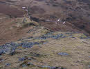 too steep to descend, so head back to its base, then curve around the southern flank of the crag. This brings us to a stone wall - cross the wall then turn right to follow it north, before turning right to head toward Hartley Crag (just before reaching a stone wall running across from the first wall).
Hartley Crag is a long finger of rock that runs west, with the main Eskdale valley on the right and a shallower drop into a small valley to the left. An easy route runs along the top of the ridge ending up in the corner of a field.
8: SD 178 994
At the base of the ridge look for a footpath that crosses the wall to the left. Cross the wall and follow the path across the corner of the next field. In the third field turn left and head for the near-left corner. Here look for a path that heads downhill, running alongside a stream and another stone wall. Follow this path down through the woods and into the level ground in the valley bottom. Eventually we reach one of the main paths through the woods. Turn left onto this and follow it out of the woods and onto a rather muddy track - turn right onto this track and follow it back to the car park.