 This walk takes us to the summit of the Old Man of Coniston from Coniston village, but avoids the standard tourist routes. Instead we go via Goat's Hause and Goat's Water, and return via Dow Crag, giving us two great summits on a single walk.
Ascent: 2,500ft/ 760m
Length: 7.1 miles/ 11.5km
Map: Explorer 06 English Lakes South West
Last Walked: 10 October 2007
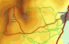
We start at the parking area at the end of the surfaced part of the Walna Scar Road. This road leaves Coniston from the crossroads in the south of teh village, opposite the road to the lake side and the ferry, heads west through the village then turns left and climbs up onto the fell side. At the end of the road a gate leads to the parking area, in an abandoned quarry.
![]() The Walna Scar road used to link Coniston with the Duddon Valley. The road is gone, but a good walkers track now follows the same route, heading south of the Old Man and Dow Crag, and crossing Walna Scar. For the moment we use this track for about a mile, until the valley of Goat's Water begins to open up to the right.
The Walna Scar road used to link Coniston with the Duddon Valley. The road is gone, but a good walkers track now follows the same route, heading south of the Old Man and Dow Crag, and crossing Walna Scar. For the moment we use this track for about a mile, until the valley of Goat's Water begins to open up to the right.
![]() Just as this side valley opens up, a clear path leaves the Walna Scar Road and heads up the right-hand side of the. Take this path and follow as it passes Goat's Water, then climbs up towards Goat's Hause. This section of the walk is rather dominated by the crags below the summit of Dow Crag, which rather loom over the path.
Just as this side valley opens up, a clear path leaves the Walna Scar Road and heads up the right-hand side of the. Take this path and follow as it passes Goat's Water, then climbs up towards Goat's Hause. This section of the walk is rather dominated by the crags below the summit of Dow Crag, which rather loom over the path.
![]() At Goat's Hause we reach the path that links the Old Man and Dow Crag. Turn right here,
At Goat's Hause we reach the path that links the Old Man and Dow Crag. Turn right here, ![]() and follow this path until it splits in two. At this point take the right-hand branch, which cuts a corner and heads towards the summit of the Old Man. After about a third of a mile this path merges with another path, and the combined paths continue on to the summit cairn.
and follow this path until it splits in two. At this point take the right-hand branch, which cuts a corner and heads towards the summit of the Old Man. After about a third of a mile this path merges with another path, and the combined paths continue on to the summit cairn.
![]()
![]() The summit of Dow Crag is similar to many of the Coniston fells, with a smooth grassy slope on one side and a dramatic cliff on the other. The difference here comes at the summit, an rocky outcrop that needs a short scramble to conquer. On our visit the summit rocks were too wet and slippery to be safe, so we took the alternative, path which bypasses them to the right. The path then continues south along the ridge, passing over Buck Pike and Brown Pike before eventually reaching the point where the Walna Scar Road crosses the ridge line.
The summit of Dow Crag is similar to many of the Coniston fells, with a smooth grassy slope on one side and a dramatic cliff on the other. The difference here comes at the summit, an rocky outcrop that needs a short scramble to conquer. On our visit the summit rocks were too wet and slippery to be safe, so we took the alternative, path which bypasses them to the right. The path then continues south along the ridge, passing over Buck Pike and Brown Pike before eventually reaching the point where the Walna Scar Road crosses the ridge line.