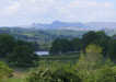
 This gentle medium length walk visits one of the tourist 'honey traps' in the Lakes - Beatrice Potter's Hill Top, before heading off into an alternative Lake District of quiet roads and empty paths, all within a few miles of Windermere's crowds.
Ascent: 700ft
Length: 5.5 miles
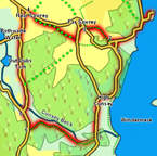
Map: Map: The English Lakes - South Eastern Area (OS Explorer Map Active)
Last Walked: June 2010
We start from the western terminal of the cross-lake ferry on the Bowness-Hawkshead Road. A foot ticket across the lake cost 50p (June 2010), and is a great way to start and finish a walk.
1: SD 390 956
There is only one possible route on from the ferry house - along the road. Sharp left then right turns take us along the headland that links the ferry house to the mainland. The route used to follow the road along the lake shore, but there is now an alternative route, following the footpath signposted for Hill Top. The first part of this takes us off the road to the right, then crosses a side road and climbs up onto an interesting terraced path. This ends with a flight of stairs that drop down towards a small car park. A permissive path then leaves the car park, running up the right-hand side of the road. This then runs out and is replaced by a similar permissive path on the left-hand side of the road.
2: SD 382 951

The permissive paths eventually run out at a t-junction. Ignore the road branching off to the left here and follow the main road up the hill. Just as this road turns sharply to the left itself leave it and follow a signposted footpath that heads up and slightly to the right. This path continues on in a straight line, running between a series of houses, before passing through an iron gate to reach a lane that drops back down to the road.
3: SD 379 943
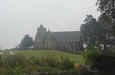
Continue along the road for a few yards, then turn left onto a side road. Follow this as it heads through the village and out towards the church. Just before reaching the church, turn right onto a signposted (and rather obvious) path that cuts across a field, crosses a stream, then runs along the edge of the next field, before turning into another permissive footpath that takes us to Hill Top and Near Sawrey.
4: SD 369 956
Continue on past Hill Top and through the middle of the village. Turn left onto the next road after the National Trust car park. At the T-junction at the edge of the village continue straight ahead. Follow this road for around 800ft to another junction. Here turn left, and follow this road is it runs between some woods on the left and open farmland on the right.
5: SD 348 940
This road eventually brings us to Eel House Bridge, which crosses Cunsey Beck, and a T-Junction with a busier road. Turn left onto this road.
6: SD 369 937
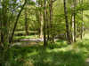
We follow this road as it runs straight, then leave it onto a footpath to the left just as the road is about to curve to the right and climb up a steep slope. Our new path soon brings us close to Cunsey Beck, and continues to follow the line of the beck all the way to another road at Cunsey Bridge.
7: SD 381 935
Turn left onto this road (sadly there isn't a way to reach the lakeshore footpath here). Follow the road towards High Cunsey, then turn right at the junction in the village and follow the road as it runs through the woods above Windermere.
8: SD 384 950
Ignore all of the minor tracks that head off to the right, and follow the road as it climbs up a steep but short slope to a T-Junction. Turn right here and follow this road back to the road to the ferry. Turn right and follow this road back to the ferry house (the small nature research at Ash Landing is worth a diversion, and can be entered at its top and bottom corners, so isn't a dead end).