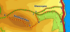
 This moderate walk takes us onto the summit of Sheffield Pike, the fell that divides the lower reaches of Glencoyne and Glenridding. The summit offers great views of the Helvellyn range, and Ullswater, and is often out of the clouds when the higher fells are covered.
This picture shows the reverse view - Sheffield Pike seen from Helvellyn.
![]() Ascent: 1,750ft/ 535m
Ascent: 1,750ft/ 535m
Length: 4.3 miles/ 6.8km
Map: Explorer 05 English Lakes North East
Last Walked: 13 October 2007
We start from the National Trust car park just north of Glencoyne Bridge.
![]() Soon after crossing the bridge, turn right onto a track that heads into Glencoyne. Stay on this track as it runs into the farm at Glencoyne, following the footpath signs to get through the farmyard. After passing the farm the track continues on to the west, running up the valley and gaining height.
Soon after crossing the bridge, turn right onto a track that heads into Glencoyne. Stay on this track as it runs into the farm at Glencoyne, following the footpath signs to get through the farmyard. After passing the farm the track continues on to the west, running up the valley and gaining height.
This track passes close to the small row of cottages at Seldom Seen, and then cuts diagonally across a large open field, climbing quite steeply up towards the right-hand end of the forest on the southern side of the lower valley.
![]() We follow this path to the edge of the field before passing through a stone wall to reach a crossroads. At this point we cross the east-west path along the valley that we will be using late, but for the moment we want the smaller but clear path that heads straight on, with the trees to the left and the eastern crags of Sheffield Pike to our right. The further we go, the clearer this path becomes.
We follow this path to the edge of the field before passing through a stone wall to reach a crossroads. At this point we cross the east-west path along the valley that we will be using late, but for the moment we want the smaller but clear path that heads straight on, with the trees to the left and the eastern crags of Sheffield Pike to our right. The further we go, the clearer this path becomes.
![]() After about a third of a mile we reach the top of the climb, and a split in the path. The left hand branch follows the forest wall and heads towards Glenridding Dodd. We want the right hand branch, which climbs diagonally across the eastern end of Sheffield Pike.
After about a third of a mile we reach the top of the climb, and a split in the path. The left hand branch follows the forest wall and heads towards Glenridding Dodd. We want the right hand branch, which climbs diagonally across the eastern end of Sheffield Pike.
![]() We follow this path until it joins another path running along the top of Glenridding Screes. Turn right onto this path, and follow it as it climbs up onto the summit plateau (on occasion this path looks like its heading for nasty drops, but it never actually does).
We follow this path until it joins another path running along the top of Glenridding Screes. Turn right onto this path, and follow it as it climbs up onto the summit plateau (on occasion this path looks like its heading for nasty drops, but it never actually does).
![]() Our path climbs steeply up onto the summit plateau. At the edge of the plateau take a diversion to the right to visit Heron Crag, a great viewpoint for Ullswater (better than the true summit). After that return to the path and continue on to the summit cairn.
Our path climbs steeply up onto the summit plateau. At the edge of the plateau take a diversion to the right to visit Heron Crag, a great viewpoint for Ullswater (better than the true summit). After that return to the path and continue on to the summit cairn.
The path on from the summit is clear, heading down the western slope to the saddle between Sheffield Pike and Stybarrow Dodd.
![]() Just before we reach the saddle, turn right onto a clear path heading back towards Glencoyne. This path curves around to the right, skirting around the northern slopes of Sheffield Dodd. Close to the start it does look as if it about to head out over a massive drop, but this is an optical illusion - as you get closer to the apparent drop, the slopes beyond come into site.
Just before we reach the saddle, turn right onto a clear path heading back towards Glencoyne. This path curves around to the right, skirting around the northern slopes of Sheffield Dodd. Close to the start it does look as if it about to head out over a massive drop, but this is an optical illusion - as you get closer to the apparent drop, the slopes beyond come into site.
![]() This path eventually brings us back to the crossroads we passed at step 3. Head straight across the crossroads, and into the wood. Our path then joins the track to Seldom Seen, which we follow back to the main road.
This path eventually brings us back to the crossroads we passed at step 3. Head straight across the crossroads, and into the wood. Our path then joins the track to Seldom Seen, which we follow back to the main road.
Where we reach the road a permissive footpath runs between it and the road. Turn left and follow this footpath until it runs out, then follow the road back to the car park.