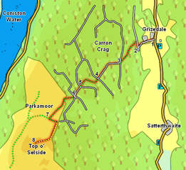
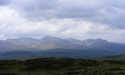
 This medium length walk from the Forestry Commission centre at Grizedale takes us out of the trees onto an area of unplanted moorland, before visiting Top o'Selside, a rare example of an unplanted fell in this area, and a great viewpoint..
Ascent: 900ft
Length: 5.5 miles
Map: The English Lakes - South Eastern Area (OS Explorer Map Active)
Last Walked:
We start at the Forestry Commission car park at Grizedale
1: SD 336 942
Head out of the car park heading towards the Visitor Centre, shop and restaurant. Ignore the visitor centre for the moment and instead turn left onto the road that runs past the left-hand side of the buildings.
2: SD 331 941
This takes us past the main buildings and their walled garden, across Grizedale Beck, past the working buildings and to the edge of the forest. Here take the path that climbs up into the trees, with open ground close on the left. After a short distance the main track becomes rather worn, and a footpath runs parallel to it to the right. This path brings us up to a forest track. Turn right onto this track, then left onto the signposted footpath that climbs up into the trees.
3: SD 327 937
This path eventually brings us to a crossroads. Head straight across onto a forest track that drops down slightly, then curves around to the left.
4: SD 323 935
This brings us to another crossroads. Once again head straight across, this time onto what starts as rough track and narrows to become a footpath. ,
5: SD 319 933
This time our path emerges onto a forest track just short of a T-junction. Head towards this junction, then take the left-hand branch..
6: SD 317 929
We have now emerged from the trees to reach a crossroads in an area that has been recently cleared. Our rote onwards takes us off the main forest tracks that meet here and onto a more minor moorland path. Head across the crossroads, then turn right onto the signposted footpath. This runs to the forest fence, then continues on across some open moorland.
7: SD 312 925
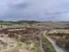
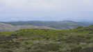
Eventually this track reaches a crossroads. Turn left here and head towards the edge of the forest. Just before entering the trees turn right and follow a faint footpath that follows the edge of the woods - the lower stretches can be a little hard to find, but higher up the path becomes clearer. Follow this path onto Heel Toe Hill. At this point the forest fence turns off to the left, while our path turns right, and runs along the ridge that leads up to Top o'Selside. Although there are a few undulations on the way, the actual summit is never in doubt, and the highest ground in the area.
8: SD 309 919
Retrace your steps to get back to Grizedale. This is a fairly straightforward route, although be careful at step five, where the correct route on is the most minor of the routes - turn right at the t-junction then almost immediately left onto our original path..