 This is a super walk, one of the best in the district, and it combines a trip on the Ullswater steamers with a classic walk along the southern shore of the lake. This is one of my favourite walks that doesn't reach a summit, with a delightful path and ever changing views.
Ascent: 1,200ft/ 360m
Length: 6.4 miles/ 10km
Map: Explorer 05 English Lakes North East.
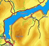
We start at Glenridding, and use the Ullswater Steamer to reach Howton, so before setting off check their web site to make sure that the ferry is running (in 2012 it should be running on every day apart from Christmas Eve and Christmas Day.
Leave the ferry at Howton. Follow the path that runs in from the pier along a spur of land. Where the path reaches the main shoreline it splits in two - take the right hand branch and follow it along the lake shore. After crossing two fields the path reaches a road that runs along the lake shore. After a short distance leave the road on a footpath that leaves to the left. This crosses a field, passes through a narrow band of trees and reaches a second path. Turn right onto this path, which runs around the northern slopes of Hallin Fell and into Hallinhag Wood.
![]() We stay on this lake shore path until it leaves the western top of the woods at Sandwick Bay. We then follow the path across a series of fields, before turning left to follow Sandwick Beck inland. This brings us to a bridge over the beck - cross the bridge, and then turn left onto a road that passes the buildings at Sandwick. Just past the last building turn right onto a footpath that climbs south-west out of the valley, before merging with a larger track. Follow this track as it runs south-west, with the open fellside to the left and fields to the right.
We stay on this lake shore path until it leaves the western top of the woods at Sandwick Bay. We then follow the path across a series of fields, before turning left to follow Sandwick Beck inland. This brings us to a bridge over the beck - cross the bridge, and then turn left onto a road that passes the buildings at Sandwick. Just past the last building turn right onto a footpath that climbs south-west out of the valley, before merging with a larger track. Follow this track as it runs south-west, with the open fellside to the left and fields to the right.
![]() This track runs past the fields, and then turns north-west, eventually reaching the lake shore. Follow the path as it runs below the crags of Birk Fell, and then runs through another wood. The path generally follows the shore through the trees, although on occasion does climb up to 100ft above the water.
This track runs past the fields, and then turns north-west, eventually reaching the lake shore. Follow the path as it runs below the crags of Birk Fell, and then runs through another wood. The path generally follows the shore through the trees, although on occasion does climb up to 100ft above the water.
![]() At the far end of this wood the path splits. Take the left-hand branch, which climbs up to the pass between Silver Crag and Birk Fell. The top of the pass is a great viewpoint for Patterdale, and is well worth the short climb.
At the far end of this wood the path splits. Take the left-hand branch, which climbs up to the pass between Silver Crag and Birk Fell. The top of the pass is a great viewpoint for Patterdale, and is well worth the short climb.
Our target now is to reach the bridge at Side Farm, one of a limited number of crossing points over Goldrill Beck. Follow the high level path south from the top of the pass for about a third of a mile, until it draws level with an isolated field containing a clump of trees. At thus point take the side-path that bracnhes off to the right, heading towards the southern end of the field. This brings us to a farm lane - follow this lane south (the same direction as the path), until it brings us to Side Farm. Turn right into the farmyard and follow the track from the farm to the main road at Patterdale.
Turn right onto the main road, and follow it back to Glenridding. This does involve some road walking, but most of the time we can use either the roadside path or permissive paths running next to it.