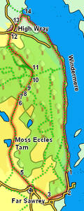
 This walk explores the north-western shore of Windermere, visiting Far Sawrey, and passing a series of small tarns (most notably Moss Eccles Tarn), before heading into the woods that dominate this area, eventually returning along the lakeshore path.
Ascent: 992ft/ 300m
Length: 8 miles/ 13km
Map: Explorer 07 English Lakes South Eastern Area
We start from the lakeside parking north of the ferry across Windermere. If that is full, try the National Trust car park just a little further south. It is also possible to start in Bowness and use the ferry to reach the starting point.
Head south from the starting point, with the lake to the left and the trees rising up to the right. Follow the lakeside road until it joins the main road to the ferry.
Our route on follows the line of the road for some way, but fortunately there are footpaths that take us out of the way of the traffic for most of the route. Once on the main road, continue on in the same direction, ignoring the first path that heads off into the woods to the right. Instead take the second path, which runs roughly parallel to the road. This path heads across a small car park, then soon after that crosses to the other side of the road. This part of the path runs along the left-hand side of the road, before emerging onto the road at a small junction.
Continue on along the main road until it begins to curve to the left. At this point turn right onto a footpath that starts in the outside curve of the corner, running uphill with a wood to its left. This path climbs up of a shoulder of the hill that the road curves left to avoid, passes a number of houses, including Sawrey Knotts, before heading down to join the main road just before the pub in Far Sawrey.
Follow the road past the pub, then turn right onto Cuckoo Brow lane and follow this lane as it climbs out of Far Sawrey.
![]() Follow this lane to a Y-junction, where we take the left hand branch. This follows a small stream, then curves towards the right and climbs up towards Moss Ecles Tarn. After this the track passes a number of small tarns, before reaching the edge of the woods. This track is rather easier to follow on the ground than on the map.
Follow this lane to a Y-junction, where we take the left hand branch. This follows a small stream, then curves towards the right and climbs up towards Moss Ecles Tarn. After this the track passes a number of small tarns, before reaching the edge of the woods. This track is rather easier to follow on the ground than on the map.